NR: Frederiksted Historic District
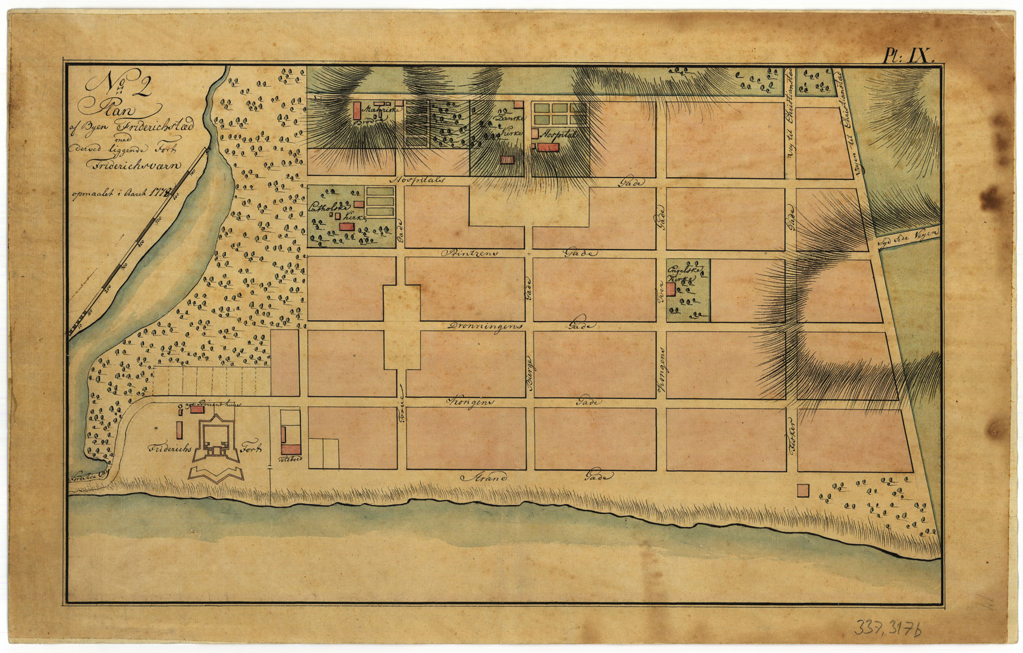
The Frederiksted Historic District was initially planned in 1751 by Jens M. Beck as a gridiron layout with two similar sections divided by a lagoon and a proposed fort. However, only the southern part was developed initially. In 1767, an additional double tier of blocks was added, and in 1875, a single block wide, five-block long tier was included on the eastern boundary. The town’s layout and boundaries have mostly remained unchanged, except for the addition of two blocks to the southeast corner in 1875.
The grid layout runs on a north-south axis parallel to the harbor, with the fort and customs house located in the northeast section. The town’s architectural style was influenced by a building code from 1747 that mandated all construction to be at the sidewalk line, regulated building materials, and controlled side yards. This resulted in low hipped roof structures, predominantly made of masonry, facing the sidewalks, with many featuring arcaded walkways at ground level. The government’s ownership of the seaward side of Strandgade adds to Frederiksted’s distinctive character.
Development of the town was slow initially, with only two additional houses constructed by 1755 besides Frederiksfort. However, by 1780, the upper section of the town had flourished, with new buildings mainly on King and Queen Streets, followed by development along the Strand. Churches were built in the northeast quadrant in the early 19th century, while the southern area remained largely undeveloped until after Emancipation in 1848.
Frederiksted has faced periodic damage from hurricanes, with significant water damage to the Strand area from a tidal wave in 1867. The Labor Riots of 1878 led to the burning of the four-block business area in the northeast, which was promptly rebuilt with ornate Victorian details. The Historic District can be categorized into three functional zones: commercial in the northeast, institutional along the eastern edge, and residential south of Hill Street. Commercial structures are mostly retail and office spaces, while institutional buildings include churches and schools. Residential buildings vary in condition, with few arcades and galleries in the institutional zone
The residential area spans five blocks from Hill Street to Fisher Street, with two additional blocks in the southeast corner. It comprises low-density residential buildings with scattered convenience stores. The structures are made of rubble masonry, frame, or a combination of both, featuring hip roofs as the predominant form. Building heights are evenly split between one and two-story structures, with many of the latter having projecting galleries. Some buildings are dilapidated, while others are well-maintained. The Frederiksted Historic District is bordered by recreation fields and open space to the north, undeveloped space and a cemetery to the east, and new low-density residential construction and public areas to the south.
St. Paul’s Anglican Episcopal Church:

St. Paul’s Anglican Episcopal Church in Frederiksted, USVI, is more than just a religious building; it is a pillar of the community, a beacon of faith, and a guardian of history. Its rich heritage, beautiful architecture, and commitment to service make it a vital part of the fabric of Frederiksted. As it continues to serve future generations, St. Paul’s remains a symbol of the enduring legacy of the Anglican Episcopal faith in the Virgin Islands. It was founded in 1812, making it one of the oldest churches in Frederiksted. The establishment of the church was part of the broader Anglican mission to provide spiritual guidance and support to the residents of St. Croix, including the enslaved African population.
The church building, constructed in the Gothic Revival style, is notable for its architectural beauty. The structure features characteristic elements such as pointed arches, ribbed vaults, and flying buttresses, which were prevalent in ecclesiastical architecture of that period.
Customs House:
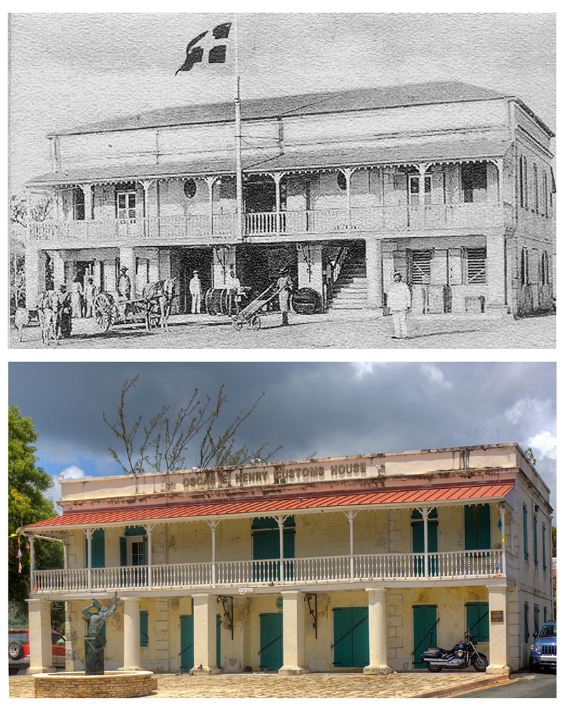
The Frederiksted Customs House was constructed in the 1840s during the Danish colonial period. Designed in the neoclassical style, the building showcases the architectural influence of Danish colonialism and serves as a testament to the island’s historical ties with Denmark.
The primary function of the Customs House was to manage the import and export of goods, ensuring that proper duties and taxes were collected. It served as the administrative center for customs operations in Frederiksted, overseeing the bustling trade that passed through the port. It was central to the economic activity of St. Croix, and facilitated trade not only between the Virgin Islands and Europe but also with other Caribbean islands and North America.
The building is characterized by its symmetrical façade, tall columns, and grand staircases. The neoclassical design includes features such as a pedimented portico and large arched windows that allow ample natural light into the interior spaces.
A fountain named ‘Freedom’ stands in front of the Customs House. The bronze sculpture portrays Moses Gottlieb, also known as John Guttliff Bordeaux, General Buddhoe, or General Bordeaux. He played a vital role in the island’s emancipation efforts. Originally a skilled sugar boiler who could read and write, he was often lent to other estates from La Grange due to his exceptional skills and leadership qualities. This unique position enabled effective communication with enslaved workers from different estates. Despite the Crown declaring emancipation in 1847, there was no significant improvement in the conditions of enslaved workers on St. Croix. Consequently, in 1848, a revolt led by Buddhoe erupted
Military Hospital:
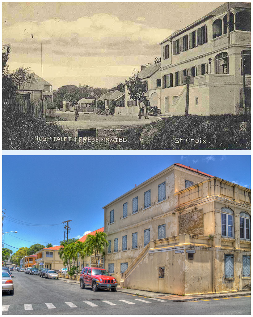
The Frederiksted Old Military Hospital, located in Frederiksted, St. Croix, U.S. Virgin Islands, is a historic building with a rich history. It was constructed in the late 18th century, around 1793, by the Danish colonial government. Its primary purpose was to serve as a medical facility for Danish soldiers stationed on the island, as well as for the enslaved African population.The building is known for its distinctive Danish colonial architecture, with its red brick walls and arched windows.
During the Danish colonial era, the hospital was a critical component of the military infrastructure, providing necessary medical care to soldiers who suffered from tropical diseases, injuries, and other ailments common in the Caribbean environment.
Cargo Crane:
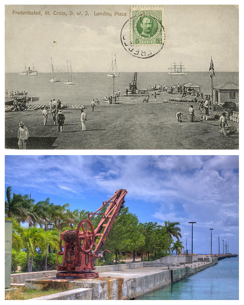
The old cargo crane in Frederiksted, St. Croix, U.S. Virgin Islands, is a historic landmark that dates back to the island’s colonial era. The crane, also known as a wharf crane or a port crane, was used for loading and unloading cargo from ships in the harbor. Unlike the present pier, large vessels couldn’t directly reach the dock, necessitating the use of lighters to transfer cargo between the ships and the dock. Loading and unloading were facilitated by a crane.
These cranes were essential for handling goods such as sugar, rum, and other commodities that were produced on the island and exported to other parts of the world. The crane in Frederiksted is a reminder of the island’s history as a major hub for the sugar industry and maritime trade.
The initial pier, essentially a dock, was constructed in 1751 by the Danish West India and Guinea Company to enhance trade and commerce in the region. In the early 2000s, a significant multi-million dollar revitalization project revamped the waterfront, relocating the crane to its current position at the new pier.
Today, the old cargo crane serves as a historic site and a reminder of St. Croix’s rich maritime heritage. It is a popular attraction for visitors to the island, offering a glimpse into its past as a bustling port town.
Athalie McFarlane Petersen Public Library:
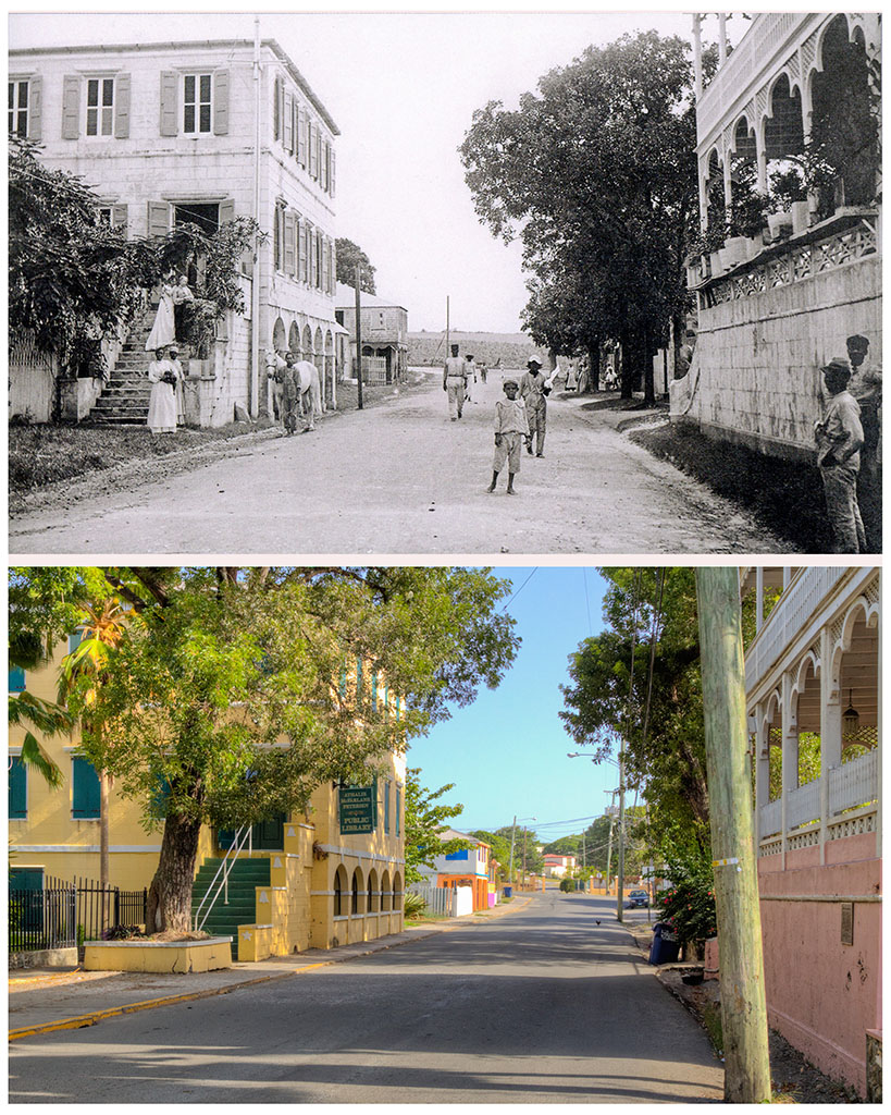
The Athalie McFarlane Petersen Public Library is situated on the southeast side of Strand Street.
It was constructed in 1803 as a private residence, showcasing exquisite Victorian architecture. Originally called The Bell House, it earned this name because the Bell family, the former owners, adorned the staircase with bells to symbolize their children.
Ms. Petersen, a founding member of the St. Croix Library Association, passed away in 2003 at the age of 82, leaving behind a lasting legacy of passion for reading.